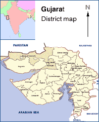
Map of Gujarat State, India
|
The State is situated in Western part of India and is surrounded by Rajasthan in the North, Maharashtra in the South, Arabian Sea in the West, Border of Rajasthan and Madhya Pradesh in the East.
| State Capital | Gandhinagar |
| Area of the State | 196 000 sq. km |
| Population | 41,309,582 |
| Male Population | 21,355,209 |
| Female Population | 19,954,373 |
| Principal Languages | Gujarati |
| Urbanisation rate | 34.49% |
| Literacy Rate | 61.29 % |
Climate
| Temperatures | Maximum: 45.5C during May Minimum: 1.5C during January |
| Average Annual Precipitation | 653 mm |
| Minerals with abundant supply are Bauxite Limestone, Lignite,Crude Oil & Natural Gas, Calcite, Dolomite. |
| Minerals with moderate supply are China Clay, Silica, Flourspar, Choke, Fire Clay. |
| The major soil type in the State are saline, plain and rocky. |
| Water Number of Canals : Nil (private) Number of Wells : 0.66 |
| Forest Area under forest cover 19379.20 sq. km (1990-91) |
| Total | 16.95 million |
| Male working | 11.56 million. |
| Female working | 5.39 million. |
| Agriculture & Allied Activities | 56.44% |
| Trade | 2.18% |
| Manufacturing & Others | 41.38% |
| State Domestic Product | Rs. 322400 million (1992-93) |
| Product Income Realised From | Primary Sector : Rs. 1,830 million 28.6% Secondary Sector : Rs. 8,191 million 30.8% Tertiary Sector : Rs. 10,512 million 39.6% |
| Railway | Total Railway track length : 5287 Kms. Number of Railway Stations : 792 |
| Road | Total road network : 68244 Kms. National Highway : 1573 Kms. |
| International Airports | Ahmedabad |
| Domestic Airports | Ahmedabad, Baroda, Surat, Rajkot, Jamnagar, Porbandar, Bhavnagar, Keshod, Bhuj,Kandla and Deesa |
| Sea | Major Sea Ports in the State : Kandla Number of minor sea ports are : 39 |
